


Nicholas Grondin, University of Tampa
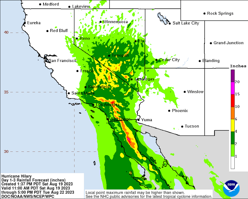
Hurricane Hilary headed for Mexico’s Baja peninsula and was forecast to speed into Southern California at or near tropical storm strength on Sunday, Aug. 20, 2023. For the first time ever, large parts of Southern California were under a tropical storm warning. Forecasters warned of a “potentially historic amount of rainfall” and “dangerous to locally catastrophic flooding.” California’s governor declared a state of emergency, and officials urged people on Catalina Island and in a few other high-risk areas to evacuate.
Hurricane scientist Nick Grondin explains how the storm, with help from El Niño and a heat dome over much of the country, could bring flash flooding, wind damage and mudslides to the U.S. Southwest.
How rare are tropical storms in the Southwest?
California has only had one confirmed tropical storm landfall in the past. It was in September 1939 and called the Long Beach Tropical Storm. It caused about US$2 million dollars in damage in the Los Angeles area – that would be about $44 million today. A hurricane in 1858 came close but didn’t make landfall, though its winds did significant damage to San Diego.
What the Southwest does see fairly regularly are the remnants of tropical cyclones, storms that continue on after a tropical cyclone loses its surface circulation. These remnant storms are more common in the region than people might think.
Just last year, Hurricane Kay took a similar track to the one Hurricane Hilary is on and brought significant rainfall to Southern California and Arizona. Famously, Hurricane Nora in 1997 made landfall in Mexico’s Baja California and kept moving north, bringing tropical storm-force winds to California and widespread flooding that caused hundreds of millions of dollars in damage, particularly to fruit trees and agriculture.
A study led by atmospheric scientist Elizabeth Ritchie in 2011 found that, on average, about 3.1 remnant systems from tropical cyclones affected the U.S. Southwest each year from 1992 to 2005. That’s a short record, but it gives you an idea of the frequency.
Typically, the remnants of tropical cyclones don’t go beyond California, Nevada and Arizona, though it wouldn’t be unprecedented. In this case, forecasters expect the effects to extend far north. The National Hurricane Center on Aug. 18 projected at least a moderate risk of flooding across large parts of Southern California, southern Nevada and far-western Arizona, and a high risk of flooding for regions east of San Diego.
What’s making this storm so unusual?
One influence is the El Niño climate pattern this year, which is showing signs of strengthening in the Pacific. Another, which might be less intuitive, is the heat dome over much of the U.S.
During El Niño, the tropical Pacific is warmer than normal, and both the eastern and central Pacific tend to be more active with storms, as we saw in 2015 and 1997. Generally, hurricanes need at least 80 degrees Fahrenheit (27 degrees Celsius) to maintain their intensity. Normally, the waters off Southern California are much cooler. But with the high initial intensity of Hurricane Hilary over warm water to the south, and the fact that the storm is moving fast, forecasters think it might be able to survive the cooler water.
The influence of the heat dome is interesting. Meteorology researcher Kimberly Wood published a fantastic thread on X, formerly known as Twitter, describing the large-scale pattern around similar storms that have affected the southwestern United States. A common thread with these storms is the presence of a ridge, or high-pressure system, in the central U.S. When you have a high-pressure system like the heat dome covering much of the country, air is pushed down and warms significantly. Air around this ridge is moving clockwise. Meanwhile, a low-pressure system is over the Pacific Ocean with winds rotating counterclockwise. The result is that these winds are likely to accelerate Hilary northward into California.
Despite the rarity of tropical cyclones reaching California, numerical weather prediction models since the storm’s formation have generally shown Hilary likely to accelerate along the west coast of Baja California and push into Southern California.
What are the risks?
The threat of tropical storm-force winds led the National Hurricane Center to its first-ever tropical storm watch for Southern California on Aug. 18. However, water is almost always the primary concern with tropical storms. In California, that can mean flash flooding from extreme rainfall enhanced by mountains.
When a tropical storm plows up on a mountain, that can lead to more lifting, more condensation aloft and more rainfall than might otherwise be expected. It happened with Hurricane Lane in Hawaii in 2018 and can also happen in other tropical cyclone-prone locations with significant orographic, or mountain, effects, such as the west coast of Mexico.
That can mean dangerous flash flooding from the runoff. It can also have a secondary hazard – mudslides, including in areas recovering from wildfires.
In dry areas, heavy downpours can also trigger flash flooding. Forecasts on Aug. 18 showed Death Valley likely to get about 4 inches of rain over a three-day period from the storm – that’s about twice its average for an entire year. Death Valley National Park warned of flash flooding Aug. 19-22 and closed its visitor centers and campgrounds.
Forecasters expect dangerous flooding, storm surge and wind damage in Mexico before the storm reaches Southern California.
Keep in mind this is still an evolving situation. Forecasts can change, and all it takes is one band of rain setting up in the right spot to cause significant flooding. Those in the path of Hilary should refer to their local weather offices for additional information. This would include local National Weather Service offices in the United States and Servicio Meteorológico Nacional in Mexico.
This article was updated Aug. 19, 2023, with a state of emergency declaration and evacuations.
Nicholas Grondin, Assistant Professor of Environmental Studies, University of Tampa
This article is republished from The Conversation under a Creative Commons license. Read the original article.


